Wednesday, September 30, 2009

OD&D Rogues revisted

A while ago I presented a task system for D&D along with some Rogue classes to go along with it. I think it is a perfectly fine system but for my commerical project I want to work with D&D not supplant it. So after getting some feed back on the full write up, I concluded that my original setup isn't D&Dish enough. I am happy with the design and the math but for people in my target audience to use them they need to be presented differently.

First off I changed the task roll to a ability roll. While in theory it could be used a universal mechanic like Castle & Crusade Siege mechanics that not what I am using it for. Instead of saying "Roll equal or under your abiity score on a d20." Or "under your ability score times 5 on a d100 roll" I am using this type of roll.

Ability Roll

In order to succeed with an ability roll you have to roll 3D6. You add your attribute score, your class modifier and any situational modifiers. If you are equal to or higher than a 20 on a 3d6 roll you succeed. If you wish to use critical successes and failures then use the following. If you roll a 30 or higher you critically succeed, if you roll a 10 or lower you critically fail. At the referee's discretion a d20 roll may be subsituted. This will give more extreme results (both high and low).

I am doing it this way for several reasons

1. Using the Bell Curve instead of a straight roll. I played enough 3.X and 4.X to dislike the crapshot that a straight d20 roll gives. In a 3d6 roll most of your rolls will be between 9 and 12.

2. I wanted to have a roll high instead of a roll low system.

In general the math works out like this; a character with +4 in an ability and a 10 attribute score has a 50% of success. Most abilities start off with a -4 to -2 modifier.

To recap what Rogues are

Characters (Rogues)

The Rogues are those who choose to sacrifice fighting or magic aptitude in favor of special abilities or excelling at certain abilities.

I know that Rogues have been used by later editions of D&D but after looking the Thesaurus there isn't really a better term for what I am trying to do here.

An example of a Rogue Classs

Burglar

Rogues may choose to start as Burglars. Burglars are trained in abilities used by secret societies, thieves’ guilds and gangs. They learn these abilities at the expense of combat expertise. Burglars can be of any alignment, and must possess Dexterity of 10 or better.
  • Prime Attribute: Dexterity is 13 or greater, character earns +15% experience.
  • Gains 1d6-1 HP/level
  • Fights using the Magic-user combat table.
  • Can use leather armor and shield
  • Can use the following weapons: hand axe, club, dagger, light mace, staff, short sword, light crossbow, dart, sling.
  • At 9th level a Burglar may opt to form his own guild and attract loyal followers. The burglar’s former associates may object strongly to the formation of the new guild.


Climbing Ability
A Burglar has the Climbing ability at first level. The character adds the higher of his Strength or Dexterity score to his ability roll.
A successful roll at -2 will allow a character to climb with a rope or a steep incline.
A successful roll at -6 will allow a character to climb a sheer face.
If the character is encumbered then he is at -2 to his task roll.

Climbing with a rope is at 12 feet per round
Climbing a steep incline is at 8 feet per round
Climbing a sheer face is at 6 feet per round.

For every level a Burglar gains +2 to his ability roll with Climbing.

Eavesdrop Ability

A Burglar has the Eavesdrop ability at first level. The character adds his Intelligence score to his ability roll.
In most cases a conversation can be overheard but often times it is too indistinct or unclear. This ability is useful to understanding these type of conversations clearly.

A successful roll at -2 will allow a character to listen through a door or shuttered window.
A successful roll at -4 will allow a character to listen to a single conversation in a crowded tavern.
A successful roll at -6 will allow a character to listen through a stone wall or other thick surface.

For every three levels a Burglar gains +2 to his ability roll with Eavesdrop.


Legerdemain Ability
A Burglar has the Legerdemain ability at first level. The character adds his Dexterity score to his ability roll.

This ability involves using manual dexterity to manipulate small objects.

A successful roll at -2 will allow a character to pickpocket a mark that is in the midst of a crowd.
A successful roll at -2 will allow a character to perform a sleight of hand trick or concealment when you are 5’ feet or more away from an audience
A successful roll at a -6 modifier will allow a character to pickpocket a mark that is alone.
A successful roll at a -6 modifier will allow a character to perform a sleight of hand trick or concealment when you are closer than 5’ feet to an audience.

A successful roll at -2 will allow a character to disable a known trap.
A successful roll at -2 will allow a character to pick a lock open with thieves picks.
A successful roll at -6 will allow a character to pick open a trapped lock or a trapped chest with a lock without triggering the trap.
A successful roll at -4 will allow a character to pick a lock open with inadequate tools.

For every level a Burglar gains +1 to his ability roll with Legerdemain.


Perceive Ability
A Burglar has the Perceive ability at first level. The character adds his Wisdom score to his ability roll.

A successful roll at -6 will allow a character to spot a target that hidden in shadow or well covered.
A successful roll at -2 will allow a character to spot a target sneaking through a well-lit or open area.
Note these ability rolls assume that the target has made his stealth task roll otherwise the target is automatically spotted.

A successful roll at -2 will allow a character to notice a medium size or large feature of an area in the middle of combat.
A successful roll at -6 will allow a character to notice a small feature of an area in the middle of combat.

For every three levels a Burglar gains +2 to his ability roll with Perceive.

Stealth Ability
A Burglar has the Stealth ability at first level. The character adds his Dexterity score to his ability roll.

A successful roll at -2 will allow a character to sneak around or hide in areas with heavy shadowed or have heavy cover.
A successful roll at a -6 modifier will allow a character to sneak around or hide in areas that are well-lit or open.

For every level a Burglar gains +1 to his ability roll with Stealth.

Burglar Advancement

Level Experience Hit Dice Save
1 0 1d6-1 15
2 1,750 2d6-2 14
3 3,500 3d6-3 13
4 7,000 4d6-4 12
5 15,000 5d6-5 11
6 31,000 6d6-6 10
7 62,000 7d6-7 9
8 117,000 8d6-8 8
9 192,000 9d6-9 7
10 267,000 +1 hp 6
11 342,000 +2 hp 6
12 417,000 +3 hp 6
13+ +75,000/level +1 hp/lvl 6


Level Climb Eaves. Leger. Perc. Stealth
1 +0 +0 +0 +0 +0
2 +0 +0 +1 +0 +1
3 +2 +2 +2 +2 +2
4 +2 +2 +3 +2 +3
5 +2 +2 +4 +2 +4
6 +4 +4 +5 +4 +5
7 +4 +4 +6 +4 +6
8 +4 +4 +7 +4 +7
9 +6 +6 +8 +6 +8
10 +6 +6 +9 +6 +9
11 +6 +6 +10 +6 +10
12 +8 +8 +11 +8 +11
13+ +2per3 +2per3 +1/lvl +2per3 +1/lvl


Other Rogue classes are Thugs, Mountebanks, and Merchant Adventurers.

Tuesday, September 29, 2009

From the Attic: My highest level 1e Character

A couple of days ago I posted my oldest character. However they were not my highest level character ever. Only one character was deemed worthy of a Permanent Character Folder, Robert the Wanderer.

His astoundingly original name had more to the 'the wanderer' rather than naming him after myself. I just liked the combo of "Robert the Wanderer".

His stats were rolled up using the method of 4d6 drop the lower, do this seven times, drop the lowest score. This was probably the most popular method in my hometown. The campaign was run by the DM using the Middle Earth map. From what little I remember it wasn't very middle earth like.

Yeah and the ink bleeding through from drawing the shields sucked. I still have one blank permanent folder left. With the OSR in full swing maybe I will get to use it. For those of you who missed on these the first time around (or never had a chance) I recommend going to Mad Irishman's site here. He even fixes the problem with having no AC on the front panel. Plus you can get adventure records to fill out.


Monday, September 28, 2009

A Fantasy Sandbox in Detail Part VII

Part VI

This is the seventh in a series detailing the 34 steps I recommended for making a Fantasy Sandbox Campaign. Today's post will cover the following step.

17. Write a paragraph describing each named geography


Amur Forest
This forest has some of the richest game on the island but it has never been touched by the Gevons or the other island inhabitants. A pack of wereboars curshed by Tavaras still resides in the forest attacking any who dare venture inside its bounds.

Bay of the Dead
Several attacks were made against the lich lord the century before crusaders from the Eainian Empire arrived. Launched by petty kings and barons the fleets were sent to a watery grave in the bay, destroyed by the might of the lich lord. There dead sailors and warriors were reawaken as undead guardians of Sable Port. After the crusaders destroyed Tavaras the bay was swept of their foul presence. In the centuries since the bay has retained its ill reputation and local fisherman avoid the area as well as the surrounding underwater denizens.

East Bay
This bay is the main landing for the island. Every day at dawn the bay becomes a riot of festive colors as fishermen hoist their sails to leave on their daily fishing runs. The fishermen return about an hour before sunset and evening twilight broken by the light of dozens of fires as the drying of the day’s catch begins. Watching this are four sahuagin stationed in the swamp that makes up the southern arm of the bay. They have cunningly dug out a watchpost amid the tangles of the mangroves. After the fishing boat leave they send out a fast swimmer to tell their brothers of any likely prey.

Mount Devon
Once a non descript rock outcrop the Cataclysm has exposed this limestone mass as the central peak of the island. It is riddled with caves carved out by the once higher water table. The lich lord Tavaras explored much of the caverns and made it into his strong hold. It is rumored that it connects to the Underearth and is why Tavaras as able to retain power for as long as he did.

The slopes of the mountain are bare offering little cover. The peak is likewise bare but high enough to have ice form when a storm passes through. The ice will melt when sky clears. Conditions are especially dangerous during the monsoons.

North Downs
These hills are gentle slopes on their north face and very steep (sometimes cliffs) on their south face. The ravines and valleys formed by the south faces were mostly filled in by soil during the Cataclysm forming some of the richest farmland on the island. During Tavaras rule dozens of Latifundas were established, worked by the enslaved population of the island. But overfarming depleted much of the region soil and the latifundias were abandoned when the crusaders liberated the island.

The North downs are split in the middle by a broad valley filled with the tangles of the Briar Patch. Legend has it that a sorcerer under Tavaras and his army were destroyed here by the power of a hierophant accompanying the crusaders.

South Bay
This bay is more exposed than East Bay to storms and not as popular of an anchorage for ships coming to Isle of Piall. Weekly barges depart Hawth and Sandpoint to Mikva. The bay is also a popular spot among the fishermen to hunt for clam and lobsters. Both the regular and the giant sized variety are abundant in the area.

South Downs
These hills are similar to the north downs. Their south facing slopes are gentle and the north facing slopes are steep almost a cliff. The eastern end of the range is used for grazing sheep and has several scattered sheepfolds. The area also several nature caves that are rumored to connect to the caverns under Mount Devon.


Southpoint

This low mountain was created when a rocky mass was hurled upwards during the Cataclysm and landed in this spot. It is rich in iron, zinc, copper along with several veins of silver. Several hundred years ago Baron William Gevon invited the Darkiron Clan to mine the riches in exchange for a share for the island’s use. Since then the mine has proven profitable making the Darkirons one of the wealthiest of the dwarven clans.

The slopes of Southpoint are bare of soil and have little cover. A steep stairway winds up and around the mountain to the peak where a lighthouse/watchtower is maintained jointly by the King of the Isles and the dwarves. Currently it is the home of Valard the Yellow mage (MU 9). Once the court mage of the king’s father he retired here 8 years ago. Nominally in charge of the tower he leaves the daily operation in the hands of his capable assistant Reynard (FTR 4).

The Midland Sea
Greatly expanded during the Cataclysm the Midland Sea now hums with the commerce of the surrounding realms. The Po Empire and the Kingdom of the Isles have been traditional rivals for mastery of the inland sea. In the last century Po has been ascendant as the wealth of their mainland territories have finally given them a lasting advantage against the Isles.

Under the waves the Midland Sea has been continually source of turmoil. Suddenly hundreds of square miles of new sea laid open for claims by the underwater realms. When the turmoil of the Cataclysm subsided the sea grab started in earnest. Initally with the support of the Dark Lord the Sahuagin gained the initial advantage. But later the Eainian Empire and the successor realms (Po, Isles) aided the merfolk, and Locathah were able to push back the Sahuagin and establish their own holdings. Despite the aid of the surface realms the balance of power still remains precarious in the underwater world.

The Dwarves recently suffered a rash of disappearance after a new vein was opened. They have closed the section and now are preparing an expedition to investigate what happened.

The Sands
The southern end of the Isle of Piall has an extensive stretch of sandy beaches stretching for nearly four miles along the shore and reaching nearly a mile inland. The area is known for their shifting shoreline which is carved anew every year during the monsoon storms. The area is noted for Giant Scorpions which also inhabits the local shallows. It rumored that Sahuagin raiding parties are seen here capturing the Giant Scorpions for their own nefarious reasons.

West Fen
This salt marsh runs for almost two miles along the Isle of Piall’s western shoreline. Much of it is soft ground overlaid by six foot strands of tallgrass. These strands are home to murderous packs of Daggerbeaks who hunt the local fauna and any unwary adventurers.


Having done nearly a dozen of these things so far one thing I have to say is get a good set of random tables together. Even right now I can use more tables. The main use is for an idea generator. You will have a half dozen good ideas and still will need to come up with dozens more. The tables help as an idea generator. Just keep rolling until something clicks and makes you go ah-ha!

Amur Forest I struggled with for a bit until I decided to use a variant of the cursed forest.

Bay of the dead was inspired by the scenes of the dead walking along the bottom of the sea in Pirates of the Caribbean.

East bay pretty much an extrapolation from all the villages I placed around it. The sails are a color bit to set the scene for the players. The sahuagin were thrown in to tie it with once of the plot elements I will developing.

Mount Devon is from the desire to have a mega dungeon for the island. The dropping of the water table makes for a ready excuse to have lots of caves. Not like we need one but hey at least mine got some plausibility behind it.

North Downs and South Downs geography comes from something I read recently about the geology of SE England. Basically formed by the different layers exposed after the top regions get whacked off. In England's case it was the Ice Age in mine the Cataclysm. The latifundas come from Spartacus and reading roman history. Nasty places for the slave inhabitants. Now have some nice ruins for small adventures.

South Bay I didn't much of feel for so I just extrapolated something from the surrounding settlements and threw in some giant sized animals to liven things up.

For the South downs I came up with the idea of caves connecting with the larger network underneath Mount Devon. You can have some low level adventure here in these cave and in the very back have that one lone passage that connects to the vast "Underearth" beneath the Island.

Southpoint. I though it would be cool to have what is essentially a giant meteorite plopped down here and is now being mined by Dwarves. Mind Flayers or other things that man was not meant to be know in here?

The Midland Sea comes from the fact if you got an island pretty much you got underwater civilizations. Since this whole area was just recently created in terms of history means thing are probably even more chaotic than usual.

The Sands come from a show called the most Dangerous Seas in history with Niall Marvin. It one of those show that are like Walking with Dinosaurs where the creatures are seamlessly integrated with the actors. One segment has going back to the Cambrian period where Giant Scorpions inhabited the land. In fact were the only animals on land. The beach covered in scorpions stuck in my head when creating this.

The West Fens comes from the scene in 10,000 B.C where the hunters got hunted by Terror Birds.

That it for Part VII, next is Part VIII.

Saturday, September 26, 2009

From the Attic: The Quest for the Oldest Character

This is a bit of a crazy thought. But I think it would be neat if we could find the oldest character sheets around, have it scanned in for folks to see and read.

I posted this thought on the various old school forums and to get the ball here is a scan of my oldest character. While it doesn't have a date I do have a sheet dated Nov 1979 and this was to me was obviously it predecessor being some several thousand XP less.

As for the familiar name I really liked the names Roghan and Zelligar from B1. Also this was rolled up with the most generous of the character rolling methods hence the bloated stats. What can I say I was 14 then. This character (and Zelligar) were my first serious AD&D characters. I started playing in the fall of 78 and rolled these guys up shortly after. They never progressed beyond 6th level as I became one of those folks who DMed nearly all the time.

Thursday, September 24, 2009

Chgowiz's does a great product

Michael Shorten known as Chgowiz has done a great job with the Swords & Wizardry Old School Reference Sheets which you can find here.

They have some character gen stuff, spell listings, and a complete monster reference. Along with a nice treasure generation set of tables that is very complete.

Now I admit these type of products are not exactly the most exciting thing in the world. But when I started doing Wild North I quickly photocopied, scanned and pasted together a set of reference sheet. Looking through the rulebook for this stuff is a pain. This is also coupled with the fact that not every chart in the books need to be duplicated. There are some that you will rarely use if ever.

When I looked through what Chgowiz did I was impressed that he made many of the same choices as I did. I feel that this product will be of useful practical benefit both in creating characters and in the referee creating stuff for his game.

So if you use Swords & Wizardry you can't go wrong with this product.

A Fantasy Sandbox in Detail Part VI

Part V

This is the sixth in a series detailing the 34 steps I recommended for making a Fantasy Sandbox Campaign. Today's post will cover the following step.

16. Write a Half Page background describing the region and it's history.


A thousand years ago this island emerged from the Cataclysm as a bare expanse of rock and soil. Whatever existed here was obliterated in the chaos. It took a hundred years for it transform from an barren expanse to a weed choked landscape and finally back to it's original wooded condition. During that time survivors, both human and animal found themselves washed up on it shores. The humans were originally from Nemedia, one of the Five Kingdoms of the Eainans. They established several fishing hamlets in and around East Bay. In the chaos of the time they manage to carve out an oasis of tranquility due to the island's isolation and the Midland Sea's plenty.

This was all shattered when scouts of the Lich Tavaras discovered the Isle of Piall. Tavaras was one of those charged by the Dark Lord to chart the islands of the newly created sea. Tavaras decided to claim Piall as his own. In 110 AC (After the Cataclysm) he landed on the shore of the Bay of the Dead with his undead army. He quickly subjugated the fishing hamlets and enslaved the populace. He used them to build the Sable Port.

From there he explored the island taking particular interest in Mount Devon. It was originally just a rocky outcropping but the Cataclysm stripped away the surrounding soil leaving the rocky core. Within the mountains was a extensive network of caves; now dry because of the drop in the water table. There Tavaras decided to establish his stronghold More slaves, and materials were shipped in through the Sable Port and up into the mountain. On the North Downs Bone Keep was established at the center of several latifundas setup to feed the growing slave population.

Tavaras ruled Piall as his personal domain for nearly 200 years. He survived the fall of the Dark Lord and collapse of the Dark Empire. He became one of the numerous petty lords striving for mastery in the shattered remnants of the Five Kingdoms. His downfall came with the arrival of crusaders from the United Church. They brought overwhelming force and besieged Tavaras in his stronghold for nine months. In the end they were able to breach the mountain and bring down the lich lord.

After the downfall of Tavaras, Piall was incorporated as part of the County of the Isles. The Isles were part of the Grand Duchy of Nemedia a province of the Eainian Empire. When the Eainian Empire split apart around 500 AC, Piall was briefly the capital of Arwold III, one of the pretenders to the Eainian Crown. After the Civil Wars it was incorporated into the Kingdom of the Isles and granted to the Gevon family. Markon Gevon was made the first Baron of Piall in 553 AC.

It was Baron Markon Gevon who invited halflings, the Hightower family, to settle the rich bottomlands west of The Sands. A hundred years later, the friendship of Baron William Gevon with the Dwarves of Kharan led to the Darkiron Clan to establish Hawth Hold to mine Southpoint.

Over the centuries Bone Keep, and Sable Port remained abandoned. The wars that led to the foundation of the Eainian Empire did not leave much time for the crusaders to scour the island of Tavaras evil. Enough remained to make the northern half of the Isle of Piall dangerous to the unwary traveller. The Barons of Piall have kept up patrols. But since disappearance of Baron Andrew Gevon 150 years ago in Mount Devon nobody has returned to explore any of the old ruins.

Today (1000 AC) the Isle of Piall is starting to emerge from relative obscurity. The nearly Empire of Po is expansionist and Piall is on the border between the Kingdom of the Isles and Po. The King has appointed a Sheriff to survey the island and to strengthened the island's defenses. The Gevons welcome the additional gold but not sure they like a royal officer in permanent residence.

Most of the peasantry are not free having been reduced to serfdom in the wake of their liberation from Tavaras. There has been several peasant revolts on the island. 20% of the human population is free; a mix of yeomen, craftsmen, and merchants.

The human inhabitants of Piall worship Veritas. There a temple in Mikva and shrines in the other villages and hamlets. The Dwarves of Hawth are devout worshipper of Veritas in his aspect as the Soul Forger. The Halflings of Sandpoint follow Dannu the goddess of the Hearth, and Healing. They pray to her to bless the crops and their homes.


Maybe there a little more than a half page there. Then again I get carried away with this part of setting creation.

I am a history buff


It helps by making you aware of the different situation people found themselves in over the century. But not necessary to write your own fictional history.

The key elements are being aware of the time line you created and extrapolate from the initial premises.

From my general history I now the Isle of Piall was effected by the following events in following Order.

The Cataclysm
Dark Lord & the Dark Empire
The Fall of the Dark Empire
The Eainian Empire
The Civil Wars
The Kingdom of the Isles.

The Cataclysm is a bit of cop-out as it greatly simplifies the original history of the island. Simply it wiped everything was there before. I could left something in Mt Devon and may use that option later on.

Since I want a central dungeon for this mini-setting the Dark Empire sequence provides me with a convenient hook to use the cliche yet useful lich lord.

The remaining stuff up to the Kingdom of the Isle is an example of probably what not to do with backgrounds. What I call Tolkein's 1,000 year stretch. If you ever looked at the timeline in Return of the King there are hundreds of years where literally nothing has happened. Indeed remember when you watch the LOTR film trilogy that nearly 3000 years happened between the death of Islidur and Aragon. And they act as if happened a few generations ago both in the book and film.

I found that you can really flesh out about 500 years with good stuff useful for your setting. More that then you either need to writing about your setting a really long time or just have huge gaps. 500 years is equivalent to the span of time from the fall of Rome to the start of the High Middle Ages. I did think of some interesting stuff with allied Dwarves and Halflings coming onto the Island to plug the time gap.

When I come to the Kingdom of Isles I pick some idea again. I figured the freed slaves would be eventually become serfs in the feudal society that rose after the fall of the Eainian Empire. This can be used to create tension within the setting. This is an example of extrapolating from the premise.

The rest of it comes from looking at the last overall map I did with all the Kingdoms. The Empire of Po is a much larger realm to the east of the Kingdom of the Isles. Po not being one of the original Five Kingdoms it must be an expansionist empire. This could provide some external tensions to the Island.

I probably should come up with some "sea" menace. I am fairly good with coming up with human cultures and getting them to clash together to generate adventures. Not so good with the sentient monster stuff. I will try to take of that oversight in the locales and Geography Section.


That it for Part VI, next is Part VII.

Wednesday, September 23, 2009

A Fantasy Sandbox in Detail Part V

Part IV

This is the fifth in a series detailing the 34 steps I recommended for making a Fantasy Sandbox Campaign. Today's post will cover the following steps.

14. Decide to place miscellaneous locales. (anything that doesn't fit a above.
15. Name your geography (don't forget islands)
Miscellaneous locales could be things like tribal ranges, political units etc anything that is tied to an area as opposed to a specific hex. In Wildlands (Points of Light I) I marked on the map the rough location of the various barbarian and humanoid tribes.

I am not going to have anything like that one this map.

Next I name the villages. Here I use the tried and true method of making up random fantasy gibberish for the human villages. The main difference between today and 30 years ago is that I make sure I can pronounce myself before inflicting them on my players. For the halfling village I pick some ye olde english village name. For the dwarven settlement I decide something that sounds like Old English of the Anglo Saxon era.


This map is small so I am just going to do a separate export for geography. Here I will display the natives stunning imaginative grasp of naming. Or not. I have a good reason for not naming the northern bay 'North Bay' as I am going to tie the Bay of the Dead to the ruins on Mt Devon.


If you been doing your own map while following along by now you have everything you need to create an outline for the next steps.

Geography
Amur Forest
Bay of the Dead
East Bay
Mount Devon
North Downs
South Bay
South Downs
Southpoint
The Midland Sea
The Sands
West Fen

Locales
0102 Lair
0105 Hawth (village) Dwarf
0201 Lair
0203 Lair
0204 Sandpoint (village) Halfling
0302 Ruins
0303 Ruins
0305 Ruins
0401 Lair
0402 Ruins
0403 Mikva (castle, town) Human
0403 Datha (hamlet) Human
0404 Carra (hamlet) Human
0503 Kathi (village) Human
0505 Lair

From your own make this list and put in your notebook, index cards, or word processor. Next post we will work on the regional background and start filling out some of this stuff.

That it for Part V, next is Part VI.

Tuesday, September 22, 2009

A Fantasy Sandbox in Detail Part IV

Part III

This is the fourth in a series detailing the 34 steps I recommended for making a Fantasy Sandbox Campaign. Today's post will cover the following steps.

11. Decide to place Population Locales note their race this includes social monsters
12. Decide to place Lairs (locales tht revolves around a home of monsters)
13. Decide to place Ruins (locales that revolves around a site)

Now for some decisions one what is here. I know the island is part of the Kingdom of Isle which is one of the Eainian Kingdoms. When setting up the geography I left the southern part of the island open. So it there I put in the various settlements.

I put a castle (the solid black dot) a couple of hamlets (triangles), and a village (diamond) around the eastern bay. I think I going to have some dwarves and halflings invited in so I put a village next to the small foothill in the southern bay and another village on the river on the south shore.


Now a couple of Lairs. It is an island so it definitely going to need some sea encounters so a I sprinkle a couple of those. One in the forest looks good then two on the relatively uninhabited western side.

Now for the ruins. The big mountain in the middle is going to get one likely a dungeon of some sort. Something in the ocean off of the south shore likely a ship wreck. Then then two more in the interior. Likely I will make them related to the central mountain ruins some how.

Because of the small map I am cramped so the number of locales is a bit dense. But that will work for this exercise. I try to sprinkle everything so there is a nice even spread throughout the map. The only clump of stuff is around the eastern bay.

Placing Settlements.

Settlements are in a hierarchy. Villages are the most common followed by towns and then cities.

In general a cluster of village will exist round a central market village that usually has a keep. The surrounding villages are about a half days travel away from the market village. Around 10 miles. The market villages holds a market about once every two weeks. Then there are towns usually a castle attached and a market that open two or three times a week. The market villages are about a day travel away from the town (20 miles). The cities in turn have daily markets and are usually the center of a network of market villages that are densely packed around the city.

Using a five mile hex map. A market village will have satellites village in the center hex and scattered around the six surrounding hexes. A town will have satellite market villages out scattered four hexes out. A city in contrast will have nearly every hex within a one hex radius with a market village and a much denser network of village out to four hexes.

The major metropolis of a setting would have the four hex nearly packed with villages and market villages along with daily caravan or convoy bringing in the surplus food for several hundred miles around. Rome had grain shipments coming in as far as Egypt.

Now most fantasy cities are often closer to the wilderness. Using "realistic" figures would result in the cities being surrounded by carefully manicured fields for dozens of miles around. I often justify cutting the historical figures by adopting the 20% rule. A fantasy society is a lot like a medieval but it is 20% better because of magic. Less disease, more food, better clothings. While the use of magic isn't spectacular the combined effect of all the magic-users and cleric result in a society that more prosperous than what existed in our own world. This means that the shear number of manor, latifunda, and farm needed to support your fantasy metropolis can be cut to a more manageable number.

The maps on this post are good examples of I how place settlements.

That it for Part IV, tomorrow is Part V.

Monday, September 21, 2009

Old School Mapping Textures

Thanks to John Cooper some of the zipatone textures used on the older RPG maps can be downloaded for free.

John Cooper's Gaming Page
This works in Internet Explorer

Textures
Woods
Light Woods
Mountain
Rough (I use this for hills)
Swamp

A Fantasy Sandbox in Detail Part III

Part II

This is the third in a series detailing the 34 steps I recommended for making a Fantasy Sandbox Campaign. Today's post will cover the following steps.

5. Grab a 8.5 by 11 sheet of hex paper.
6. The scale should be so that it represents a 200 by 150 mile region
7. Draw in mountains
8. Draw in rivers
9. Draw in hills using them to divide the region into distinct river valley
10. Draw in vegetation (swamps, forests, desert, etc)
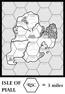
Because of time constraints I am going to detail just a large island in the Kingdom of the Isles. It will be called the Isle of Piall.

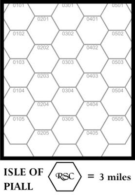
First I setup my hex grid and scale. Instead of 5 miles per hex I am going with 3 mile to hex to give a little more detail.

If you want to methodically map your setting then I suggest you read this post on mapping with hexes.


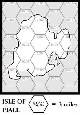
Then I draw the coast line. Don't forget things like lakes and smaller islands. Note here I added some small island in the eastern bay.


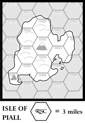
Then I add the mountains. Because I am working an island I am going ahead and add hills. Note that I am going to use a symbol map as it is probably the easiest for a novice to get going with. Feel free to use whatever style of mapping you prefer.

An island will have a central mass and possibly several adjacent masses forming peninsulas. These become the mountains, foothills, and hills of the island. In between are the island's lowlands.


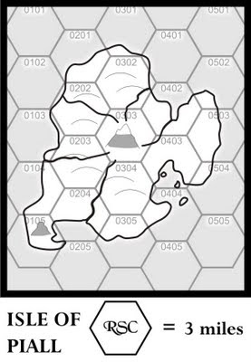
Then I draw rivers making sure they go downhill.

Since the map is small and just an island I am not going to worry about the hill and drainage of step 9. I will have some advice for this step at the end of the post.

Next we draw in the vegetation which include forest, swamp , and sand. While a desert would be out of place an area of extensive beaches perfectly plausible. So I pencil one in along the coast in hex 0305.

Swamps often form along coastal regions so I place two of them. The island isn't big enough to form much of a rainshadow anywhere. I already determined that the monsoon rains needed for agriculture comes from the south. I think it logical that I reserve that area for settlements. So I put a pair of forest in the northern areas of the island thinking that the locals haven't had enough time to clear them.


Next is Step 11 putting in settlements.

Drainage

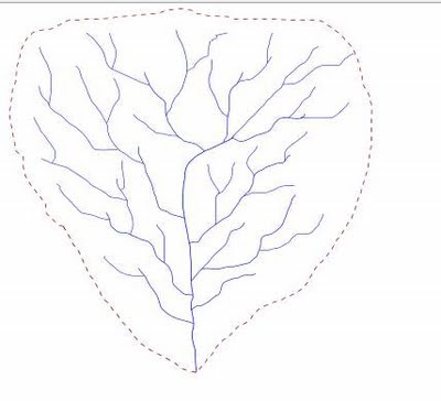
The reason you want to learn a little about drainage is that it helps to place the hills. Especially on large scale maps. A typical drainage


Much like a tree with the mouth of the river at it's base. The edge of the drainage basis will be the local high ground and often be considered hill terrain.

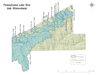
My home area has a straight forward example of what a network of drainage basins look like.


At the boundary of the drainage areas are high ground and around here and is somewhat hilly when you a mile or so inland. If I was mapping this as a setting I would place a line of hills that parallels the shore about 5 to 10 miles in. Then in between the Conneaut Creek basin and coast I would put some hills. And then add some hills along the southern edge of the basin.

Also the peninsula in the center of the map is a huge sandbar known as Presque Isle. It several miles long and has several excellent beaches. After writing this is when I decided to add the large sandy area to the map.

That it for Part III, tomorrow is Part IV.

Saturday, September 19, 2009

A Fantasy Sandbox in Detail Part II

Part I

This is the second in a series detailing the 34 steps I recommended for making a Fantasy Sandbox Campaign. Today's post will cover the following steps.

2. Label important regions
3. Write one page of background giving no more than a handful of sentences to each region.
4. Pick an area roughly 200 miles by 150 miles

First I start by labeling some important geographical features. I am not going to spend a whole of time naming everything. I am going to focus on a small area first. But it helps to have something named for consistency and later expansion.


Now I need to do a one page background of this area. To do that I need to get an idea of who lives here and how this all came about. First thing I think of is that I want a really big cataclysm to have happened. I came up with the following.


Pretty severe change probably best to have it happened a thousand years ago otherwise I would have a desolate interior.

At this point I am sure you are seeing all my nice computer generated graphics. You do NOT have to do this. You should take your base map and make six to dozen photocopies and scribbled notes.

Also you going to see an elaborate step by step evolution of the region's history. Again you would be doing this (as I do) on your photocopies sketching here, making notes there, erasing and doing new notes.

I write a history often I go on
and on
and on

Soon I have lost the point of the exercise. What I do instead is sketch out a series of basic historical maps. Then write my history off of them. It allows you to see the big picture of your timeline in a very graphical and condensed format. Again I did these on my computer so you see clearly what I am doing. Normally I just be scribbling on paper.


So I start by placing where I want the races to be. I am going to go for a World of Greyhawk style here with distinct realms for everybody. Like Greyhawk the humans will be driving the dynamics of the time.

For my initial human culture I am going to call them Aegyptus. Yes I know not the most incredibly imaginative name. I am think tho that at some point I like to run the Desert of Desolation series of AD&D modules and I want a good place for them.

The Aegyptians delve too deep into magic and cause their fertile river valley in the midst of the Goshen Desert to drive. Two group migrate one to the northwest and the other to the southwest. There they establish the lands of Illyria.

There they expanded throughout the Sheltered Sea and got into more than a few fights with the demi-human realms.

Now I am a big fan of migrations and cultures clashing. And what better way to cause trouble than to have a new nation of humans migrate right into the Illyrian. I figure that the NW group of Aegyptians cause a bunch of trouble to the west. This lead to a large group of tribes called teh Eainians to migrate east. They ran into the Illyrian Empire and taking advantage of a civil war proceeded to crushed.

The Illyrians were shattered into competing city-state and lost everything except for some large islands in the Sheltered See and the southern end of the western peninsula.

Th Eainian tribes eventually consolidated into the Five Kingdoms Lor, Canberra, Bastam, Vandenberg, and Nemedia. They also had fairly good relations with the demi-humans. Allying with them at various times during the Illyrian Wars.

Well unfortunately for the Eainians history doesn't end. I going to for the cliche Dark Lord. He is a Illyrian mage who turned to evil during the Illyrian Wars. He eventually wound up in the far north which was the home of number humanoid tribes like kobolds, goblins, orcs, bugbears, ogres, etc. By his wit and charisma he unites the tribes.

In preparation for the invasion he creates the Cataclysm shattering the heartlands of the Five Kingdoms. The invasion is almost a footnote. In the wake of destruction and war the Dark Empire is established and put the free people of the land under the yoke.

The only ones who remain free are the demi human realms using the Westwall and the Cloudwall as a bastion. And the Kingdom of Vandenberg who fortify the Green Mountains and maintain to hold off the onslaught of the Dark Lord.

Inspired by the newly formed United Church of Delaquain, Sarrath, Thoth, and Veritas, Vandenberg becomes the core of the Renaissance. Delaquain is the Goddess of Honor and Justice. Sarrath is the Dragon God of War and Order. Thoth is the god of wisdom and knowledge. Veritas is the god of truth and law.

With the demi-humans as their allies they advance northward against the Dark Empire. It takes three centuries but the Dark Lord was killed and his Empire shattered. In it's wake Vandenberg is reborn as the Eainian Empire.

The Eainian Empire golden age last for two centuries. But it's heart, the United Church was a fragile alliance of gods. Eventually greed and the lust for power overshadowed duty and honor; civil war and religious strife stalked the Empire.

Whole regions declared independence which in turns suffered their own wars. The Eainian Empire shrunk back onto Vandenberg where it came under the sway of the Church of Sarrath and was renamed the Ochre Empire in the Dragon God's honor.

Now a thousand years after the Cataclysm the land is a patchwork quilt of realms dreaming of past glory. A few realms like the Empire of Po have turned from the past and now looking forward.

So now I have a basic region with a history, some geography, and a lot of realms. In the above map I highlighted a large rectangular area. This is about how large the recommended campaign would look on this map.

However for the purpose of these posts I am going to detail a slightly smaller area. I do want the result to be useful to you guys after we are done so I am going to look for something fairly self contained. A large island in the Kingdom of the Isles looks about right. You can see it marked to the right of the large rectangular area.

That it for Part II. In Part III we will take that island and draw ourselves a proper numbered hex map. I will be attending Sibcon in Butler PA on Saturday the 19th so Part III will be out on Monday.

Friday, September 18, 2009

A Fantasy Sandbox in Detail Part I

This is the first in a series detailing the 34 steps I recommended for making a Fantasy Sandbox Campaign. Today's post will cover the following step.

  1. Using one page sketch a world or continent map
You can just grab an 11 by 8.5 sheet paper and start sketching away. Or you do a ton of research into climate, oceanography, and tectonics and do some serious world building. If you are into that then I recommend this free download e A Magical Society: Guide to Mapping by Expeditious Retreat Press. It distills the relevant science into a easy to digest format.

If want a little realism but not have to wade through so much stuff I recommend remember the following three things.

Air Circulation

Above is an idealized map of air circulating around a sphere like the earth. In reality things are more complex but here we are just worried about gaming reality. Each line of latitude is about 69 miles. Typically I just make a nice even number like 60 miles. For this particular sandbox I am going with 80 miles per degree. Each 5 degree ban represent 400 miles.

The key features are at the equator, 30 degrees, and 60 degrees. In order

The Equator is typically a low pressure area with frequent but mild storms.

North and South of the Equator are the tropical zone with winds coming out of the east

At 30 degrees North and South are the dolrums. Here the wind dies down. Your major deserts will be found along this band. It is also a barrier to sea travel.

Between 30 degree and 60 degrees are the temperate zone with winds coming out of the west.

The 60 degree band is another storm band and it is far more severe then the equator. Cold air masses from the poles will break off here and travel from west to east. On the eastern side of a continent, where this band crosses from land to sea is a major storm zone as weather from the west can hit weather carried by the current coming up from further south. (See the Perfect Storm).

The polar zone are cold with winds coming from the east.

When you draw your maps remember that mountains have a rain shadow effect. On the side where the wind is coming from it will be wet. On the other side it will be drier. If it in the Doldrum it may be barren desert stretching for hundreds of miles from the other side.

Just draw your map and superimpose the above graphics to get an idea of how things will look.

Monsoons

You can get away with some odd climate by remembering the monsoon effect. Any time you have a body of water that goes north-south with land at the high latitude end you are going to get monsoon weather. What happens is that during summer the land heats up driving down the air pressure. This sucks moisture from the body of water which travels north (or south until it reaches lands where it dumps everything.

Then in autumn it can reverse as the land cools forming a high pressure causing code air to rush off the land into the water. Any island or land on the other side will get heavy rains as well.


Ocean Currents


Ocean Currents can be easily simplified for gaming. Basically they form in circular gyres as you see above. Clockwise in the north and counter clockwise in the south. The polar regions have currents moving from west to east. What you are looking for when drawing continents is where the current hit land. When they hit they will turn clockwise (north) or counter clockwise (south).

The basic rule is this.

For a Northern Continent.

The east coast will have a warm current running north along it's coast that will go out into the ocean. If another continent is close enough to the east. Then that continent northwest shore will be warmer than normal.

The western coast will have a cool current coming from the north moderating the climate.

These effects work from the equator to 60 degrees latitude.

The southern continent would be the reverse with everything in a counter clockwise direction.


So I decided to draw a continent for this exercise. So I started with this.

I draw just the coast and mountain ranges.


Then I decide on a scale and play around with the latitudes until I wind up with this.
I want a desert on the west side of the big peninsula. But I want the interior to be normal climate.

The west side being desert is easy if it is in the doldrums. But the interior is going to need a monsoon effect for rain. The big mountain range to the north and east makes this plausible. The mountains will heat up in the summer drawing moisture from the southern ocean and the middle sea. Then in autumn the effect will reverse. The small mountains running along the south shore will be old worn down mountains so they won't have much of a rain shadow effect. The southern islands will be some of the wettest places in this region.

With that in mind I pencil in the rivers and forest.

That it for Part I. In Part II tomorrow we will write a short background and label some regions.

Thursday, September 17, 2009

A Question for my Readers: Comics

Whether you like the post itself. Did you like the use of a comic strip. Were you OK with clicking on the three images in turn to read the post. Or would you rather have them full size.

t don't have plans making comics a regular feature but since I got my tools setup to make them (My Comic Creator) I plan to use the format from time to time. But I want to do it in a way that easy for you guys.

Also another question for the crowd, how do you make a full size image appear in your post?

Into Dwimmermount

James Maliszewski's Play by Post Dwimmermount campaign has started!

You set at from Muntburg shortly before dusk, hoping to arrive at the Red Gate shortly before Areon reaches its zenith in the evening sky. The journey is uneventful, for the wilderness surrounding Dwimmermount is seemingly devoid of animal life. Indeed, the lack of the usual nighttime sounds is mildly unnerving. The terrain itself is rocky and dry, with strange shrubs and twisted trees spread across the northern slopes of the mountain, as you trudge on toward the Gate.


In time, you come across the Stairs of Mavors -- the Path of War -- carved by the Thulians centuries ago and leading up to the Red Gate. Your trek becomes much easier, although the purple-tinged air that surrounds you, often illuminated by dim purple sparks, does little to ease your minds.

The Red Gate itself is an impressive bit of handiwork, a huge metal portal carved from the metal sages call areonite, for it is closely associated with the Red Planet. Standing taller than a Man and strangely absent any markings except the shield and spear of Mavors, it gleams in the moonlight -- a sight unlike any you expected to see on this lonely mountainside.

When at last Areon rises in the sky, you are momentarily worried, for nothing seems to happen. Then the Red Gate does more than reflect the dim light of the far-off Red Planet; it magnifies it. Soon, a red glow grows and seemingly consumes the Gate itself, which fades away, leaving behind an open portal and a set of stairs descending downwards.

If the legends are true, the Red Gate will remain open till sunrise tomorrow. You have that much time either to enter and escape or find another means to do so, lest you be trapped inside for three months -- assuming you survive at all.


This initial post really grabbed my attention. It is very evocative and words like Areon, the Red Gate, the Stairs of Mavros - Path of War appealed to the Tolkien geek in me. Gives the right hint to the history of the place. It needed a little editing but then so do my posts. Looking forward to seeing what other mysteries are found here.

You can catch all the action here.

Wednesday, September 16, 2009

Referee Rumblings: Putting it all together

Today's post conclude this series of Referee Rumblings with 'Putting it all together'
Note the square boxes are folk thinking rather than speaking out loud. To see the full size comics just click on each image.


Tuesday, September 15, 2009

Referee Rumblings: Miniatures

The use of miniatures is one area that gamers are divided about. For me I am a GM who loves using miniatures. But as the picture shows below those are those with a different opinion about the use of miniatures.


I have some tips and trick for using miniatures without bogging down your game. But first off yesterday Alex asks how I keep my tiles sorted. To the left of where I sit when refereeing is this bookshelf.


Yes I REALLY like GURPS. That beside point. The second shelf down is where I keep a lot of the tiles I use during the game.


I use mainly just the really big tiles and a selection of the smaller bits. I keep the big tiles stacked up on the ends of the shelf. The Wizard's Dungeon on the left and the Chaosium Path tiles on the Right. In the baggies on the right are the smaller Chaosium tiles along with the baggies with the dungeon tile bits I use.

To the right of bookshelf you can see the my miniature storage cases. Below is a closer view.


Over 30 years of gaming I collected quite a few. Recently Tim of Gothridge Manor gave me his sets doubling my collection. I must confess I don't really use every miniature there. The one on the left is monsters and humanoids while the one on the right is used for NPC and PCs.

Also I have to confess that I use the smaller dungeon tiles rarely. I have manage to collect a bunch of plastic, plaster, and resin pieces I use for dungeon dressing.

The plastic ones I keep in my Dice box.


They come from the various Mage Warrior Dungeon Sets. They were good prices too and I wish I had more of them. Note the empty compartment are storage for miniatures when I referee away from home.

This is the box of plaster and resin dungeon dressing I use.

The top two are pillar bases, bottom left are tents. The next one to the right is a stone fence and supply barrels. Then in the bottom middle are my tavern pieces, above that is a door and a fireplace. Then to the right are bedding both regular beds and floor mats. Upper right are fireplaces and the lower left are low stone walls.

I could have gotten all kinds of crazy stuff but I choose these items because they are used in 90% of the encounters I run in fantasy games.

And that key to using miniatures and dungeon dressing. It isn't a matter of having all your stuff sorted but having the stuff you use 90% of the time easily accessible. Out of all the miniature boxes the following four are what I use the most often

This is the box where I store large quantities of the same miniatures. I basically got most of these from sales on stuff for miniature wargames. Out of this box what I use the most is in the lower right corner, the peasant/normal folk area. Here are figures presenting well .. normal people. So when I need a mayor, a barmaid, or anything similar I pull it out of here.

Next are my Official Guard Figures

When you see these guys coming you know your characters are in trouble. The Red guys are my Official Guards and the Blue Guys were Tim's Official Guards.

Next is my Orc box. Nothing but Orcs. Circled are the miniatures I use the most often for Humanoids. I have goblins, bugbears, and kobolds but no where in the quantity of my orcs. So I throw the guys in the upper left in to flesh out the few I have.

In the monster box below I use the circled miniatures a lot. They are various four legged wolves, dogs, and great cats. Useful for any mundane four legged carnivore. As you saw previously I have the herbivores covered as well. Those were gotten from a model railroad shop.

As for the remaining miniatures I set some of those aside for important NPCs. If the next series of adventures involves say undead, or giants. I will pull those figures out so they are handy. The way my games goes usually I can prepare for a session or two ahead of time. Beyond that who knows where the PCs will end up. The players have the run of the PC boxes to find just the right figure for their character.

Next post putting it all together.

Monday, September 14, 2009

Referee Rumblings: Dungeon Tiles

In the last post in this series I talked about Battlemats. The problem with Battlemats is that they are either totally blank in which case you need to spend time drawing what you want. Or they are specific to one encounter or one type of encounter. Is there a middle ground?

Dungeon Tiles

The above picture probably is recognizable by the majority of gamers as belonging to one of Wizards of the Coast Dungeon Tile sets. They have good art, durable, and somewhat inexpensive. In addition to Wizards of the Coast, there are many third party outfits producing dungeon tiles and their 3D variants. It is a staple product for many PDF publishers as you can see when you browse RPGNow's top 100 list.

Dungeon Tiles have been with the hobby since the early 80s. Probably their original inspiration was the Geomorph series from TSR. Once the geomorphs were out there it was natural to expand them to full scale for 25mm minatures. (1" = 5').

Some of the early set were quite gorgeous for the day. Chaosium produced Fantasy Paths, Village Paths, and Castle Paths.

I found them difficult to use because they don't really fit together well. But they had some great individual tiles that I used over and over again. The tavern on the lower right is probably got the most use.

There were others.


I don't know who the two. The one in the upper left was designed with a magnetic base and designed to fight on to a metal board. Unfortunally a decade the glue holding the base deteriorated and half them are missing the base (along with the board). The one on the right is the one I used the most. It was a bit of pain because the small 10' by 10' tiles had borders you wree supposed to use in laying out the dungeon. Never had enough corners to do what I want. Plus it slowed down deployment unless I had everything sorted just so.

Of the early tiles only the doors I continue to use

In general I find Dungeon Tiles, regardless of sets, useful in limited circumstance. The main problem is keeping them properly sorted for deployment. The current generation is way better than what I started out with back in the day. What I like about today's dungeon tiles are the "bits" As shown below.


They are little pieces of scenery that I toss out to dress up something I drew on the plexiglass. They are easier to keep sorted because their small size. I find myself using the real large pieces as well. It is easy enough to keep them on a nearby bookshelf to pull and assemble into a battleboard.

I think the best use of tiles is still the traditional dungeon drawn on the grid. The pieces are similar enough that sorting is rarely an issue and I find tossing out tiles can be faster than drawing.