Yesterday I asked about the age demographics of a medieval society. Thanks to Joseph, Todd, Patrick, CastleMike1 over on the HarnForum, I was able to find what I was looking for. Joseph sent me some population pyramids. Using that as reference while using Google books search and image search, I found this in a biology text.
Which is very much like the population pyramid of many third world countries. Like this one from Angola. Which is also a reminder that as humans we still have some work to do to make the world a better place.
So what this useful for in tabletop roleplaying games? Say you want to flesh out an entire village. Even for a small village the detail can be overwhelming. This coupled the tendency of people to pick certain numbers over others resulting in a strange looking place, like my initial pass on Kensla for Scourge of the Demon Wolf where I had 75% of the population as children. So I want a baseline to see how many old people, middle age people, and so on there on.
Nicholas over on the Harn Forum pointed out that Family Tree on Lythia.com has some stuff in it. Sure enough on the age table there is a Current Age column which is the same as a population pyramid pyramid. I don't need to break it down by year by year so I used a spread sheet and came up with this.
Just take the population of the village and multiply it by the percentage to get the number of people of each age. If you want even more detail you can use the Family Tree articles. I divided the age cohorts unevenly.
All the children 13 and under are in one group. Since most medieval started giving adult responsibilities at age 14, I made an age group from 14 to 17. Then a young adult group of 18 to 25, where most are unmarried, then a group 26 to 30 of young married couples. Most medieval men didn't start until their late twenties because margins were so thin that you had to establish yourself before getting married and have kids.
Hope this is useful in detailing your own settlements. I will clean up my spread sheet and post it.
▼
Tuesday, July 26, 2011
Monday, July 25, 2011
Medieval Demographics, a question
Where can I find a population distribution of different ages for medieval societies? For example data that looks like age 60-65 is 1.3%, age 55-60 is 6.3%. In some of the projects I am working I am detailing entire villages and it would help to have a baseline to work from.
Friday, July 22, 2011
Now that is service
I been a regular buyer of Harn material for nearly 25 years. A couple years ago I decided to subscribe to Harnquest to get the latest articles at a price break. The way it works is that they put together a package of harn related articles every quarter or so. Send an email to let you know what the charge is, bill you, and then two or three week you get the latest harn articles.
For the gaming industry this approach has failed more often than it succeeded. But Columbia Games has been doing this for years and earned my trust. Harn material is uniformly excellent in quality. There is a sense of pride and craftsmanship that goes into them and it shows at Columbia Games and in the community over on the Harnforum.
However they do have premium prices, which can be off putting to many gamers who wonder if they are worth the price. However they do have a great $10 deal on the core Harnmaster rules. Also they make cool wargames that uses wooden block for unit counters, which allows them to incorporate fog of war into the game.
In the spring I updated my credit card info with them and changed my email address. They missed a letter so sent email to another Robert Conley. So how they handled it?
The vice president of Columbia Games,Grant Dalgliesh, called me to get it straightened out. How cool is that! We chatted for a few minutes and I thanked him for all the good work they done over the years and for being the main inspiration for me getting into cartography.
Now that is service.
Wednesday, July 20, 2011
I showed up, played, and died.
And it was a lot of fun.
Tim recounts much of the session here. Tim did a great job refereeing, and Dwayne expertly used the full capabilities of his character.
Looking from the outside lead up and the encounter itself were incredibly interesting, but trying to figure out the best choices for Paltar was an exercise in frustration that night. For me, the best choices means not trying to figure out what I would do, but what would my character. The thing that I like the most in playing tabletop (as opposed to refereeing) is being the character I am playing while at the table. Some of my frustration stems from the fact that Paltar was clearly in a situation beyond anything he trained or prepared for.
But it not Tim's fault that it happen. Sure he the referee, sure he wrote the encounter, downloaded that cool picture, etc, etc. Why it isn't Tim fault? Because it was my choices that resulted Paltar being in that situation.
There were several opportunities for a different set of circumstances to play out. I could have headed back to City-State instead of sending Lazarus. Despite the bum arm from the previous' week undead attack, I figured I was better choice because I had a large shield and could defend Cal, our mage, better. Lazarus was a sword and buckler fighter.
I didn't have to go into the woods to lure the thing out. But I did and that was that. My only regret that I wish I could have hung on for one more round so I could have Create Fire it's ass while we were in a Very High Mana zone.
In the end Paltar died a heroic death, and now I got to come up with a new character. I am thinking about playing either a Tharian HorseLord, a Cleric of Sarrath (Set), or a Myrmidon of Sarrath (Set).
The way we play clerical magic with GURPS is using the Unlimited Mana system out of GURPS Thaumatology. The upside of unlimited mana is that you don't spend fatigue for spells, just cast and it is done. However the fatigue that would have been spent get added to a tally. If your tally crosses a threshold, then "bad things" happen. I.e. you get to roll on the calamity table. Where results ranges from you getting a tail, to permanently destroying the mana in a region
With our variant your tally get reduced only by performing acts of piety. Daily prayer restores a small amount, more import acts of faith reduce the tally by larger amounts. It is a nice contrast to the standard GURPS Magic system. I detail the variant here.
So tonight I am going sit down with GURPS Character Assistant and see what I get for 120 point.
Friday, July 15, 2011
Of Mythago Woods and Faerie Wolds,
Richard Holdstock wrote a great fantasy novel called Mythago Wood. Centerpiece of the novel is the mysterious Ryhope Wood. I am not going into detail about the novel itself. The part that really inspired me was the fact that Ryhope Wood was larger on the inside than the outside. Much larger.
When I read this in the 80s, I challenged myself to come up with a to come up with gamable way of mapping something like this. I only have half of the original handdrawn map so I dug through what I recently drawn and threw together some examples of doing this.
I call places that are larger in the inside than the outside Faerie Wolds.
First think of a line. This represents the normal world.
Next think of a line with a mushroom like shape protruding upwards. It is connected to the line by a thin neck. This is a side profile of a faerie wold. The following diagram illustrates.
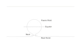
So how you map something like this? First you draw the outline of the next. This regional map of City-State from my Majestic Wilderlands shows an area that is the "neck" of a Faerie Wold.
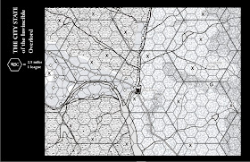
Each small hex is 1 league, or 2.5 miles. The distance a person can walk in an hour. The larger hex is 5 league. The hex that show up on my large scale maps. Note near the upper right corner near the letter G is Savernari Vale. This valley is noted for it's uncanny nature and is avoided by Purple Claw Orc, Orc Bounty Hunters, and City-State Patrols.
The neck of the Wold is the dashed line. Note it is an irregular shape, for your first attempt you may want to try doing this with a circular neck and polar plot sheets, but any shape can be used.
Next I grab a piece of paper, hex, square, or plain, that you are going to map with. I recommend that it be a lot bigger than than the size of the next. Draw a outer boundary far away from the neck. This outer boundary represents the equator of the Faerie Wold.
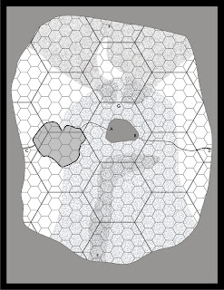
Next grab another sheet of mapping paper and redraw the exact same outer boundary. When drawing the outer boundary keep in mind you want to make it easy to locate corresponding points on the edge for when the players crosses the wold's equator.
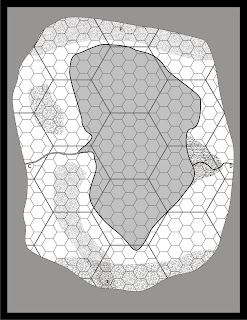
Next take any terrain feature that enters through the next and draw a little bit of them coming through the neck boundary on the first wold map. After you sure you have it lined up, then map away. When a terrain feature cross the equator note where the points are and make corresponding marks on the other wold map to continue the feature. The example wold above show how I handle rivers, forest and hills.
So how this does it work. A group of players are traveling up river and cross into the Wold at point A. They continue up river traveling to the left on the first Wold map (representing the bottom half of the Wold), until they hit Point C.
Now they cross over onto the second wold map, at point C. Continuing travelling up river and wondering why it is getting larger. Then they hit the sea at the top of the wold. They are lucky and manage to make it to the river on the other side and continue through the swamp, still going up river the whole time, exiting the top half at point D.
They still continue going up river, noting it is finally narrowing as expected. Eventually they cross the neck boundary at point B remerging in the real world. Throughly confused at travelling 34 leagues instead the expected 3 leagues.
Depending on how big the wold is compared to the neck it can be easy to get lost in one. The party can keep to going in circles until they manage to find the neck boundary again. You can be tricky and put duplicate terrain to confuse the issue further. Note on the first wold map, point G, this is similar to the gap in the hills marked at Point G on the City-State map. A party traveling south would enter the wold and head to Point and see the expected gap in the hills.
Next I will write about how to apply this to dungeons. You haven't seen a funhouse dungeon until you been in one with a wold inside of it.
Wednesday, July 13, 2011
Gone Reading
The latest in Martin's A Song of Ice and Fire, A Dance with Dragons. So far it pretty good, I like the Tyrion chapters the best. The opening prologue is pretty interesting and I am sure many will mine it for ideas for their fantasy campaign. It is an interesting insight into what many gamers would consider a monster/villain point of view.
Sunday, July 10, 2011
There is going to be a feast tonight!
A least for a bunch of miniatures.
These were originally plaster castings that I had for nearly two decades. It took me a couple of weeks to complete these as I only have two or three hours to do this. Some of the hardest part was figuring out what the various blobs of plaster were. Plus how to paint food in the first place.
Overall I am pleased with the result. One trick that worked was dry brushing some brown onto the bread and the turkey/chicken. I painted the cheese a base yellow then brushed on some dark yellow to make it look well.. more cheesy. The hardest part was figuring out how to paint the roast/ham. What I settled on was painting it flesh, then some blood red dry brushing, followed by dark brown dry brushing. For the blobs on the roast platter I figure they were onions so I painted them ivory and dry brushed some more brown onto them.
Friday, July 8, 2011
Return from the West
I got back from visiting my father and sister in Phoenix Arizona. This trip we headed north to Flagstaff to do some back road driving, caving, and swimming in waterholes. Several years ago a previous trip into northern Arizona to the Mogollon Rim partly inspired Southland. This trip was equally inspiring.
In the eastern United States the flora and fauna is largely determined by how north and south you are. In the western United States it is determined more by the altitude. We started in Phoenix which is roughly a 1,000 feet above sea level, and ended up in Flagstaff which is a little under 7,000 ft. Driving around we got as high as 8,000 feet.
The changes in terrain are dramatic. Phoenix back country looks mostly like a construction yard littered with rocks with Saguaro cactus dotting the landscape. Driving further north you find yourself in a similar region but instead of cactus you see juniper trees. They look more like man high bushes than a tree. Occasionally you will see three of a brighter green that mark stands of cottonwood trees along a stream.
Finally after climbing onto the Colorado Plateau you get into the Coconino National Forest and it extensive forest of Ponderosa pines. There is virtually no underbrush the forest floor is carpeted by grass turned yellow in the midsummer sun and littered with numerous pine cones. Deadfall can be an obstacle in some area. Despite the lack of underbrush the number pine trees break up line of sight and makes it easy to get lost if you are not paying attention to where you are going.
The landscape is broken up by dramatic mountain ranges and places where bare rock is exposed. We went to one place where the indian culture of the area used a vertical rock face not only to carve sacred pictures but also a solar calender that used the shadows cast by protruding rocks. Nearby there was a public swimming hole where the creek passed through an area of exposed rock forming a natural cliff on one side that you can jump off of.
Finally we headed to a cave that was once a lava tube. Most of the mountains in the region were formed by volcanism. This area the lava flow harden on the surface quickly but underneath it flowed out leaving behind a long snake like cave. An interesting feature is that the cave is 32 to 45 degrees all year around.
The cave entrance is a rock filled bowl and when you climb down into you can feel the dramatic changes of temperature, like walking into a refrigerated meat locker. The cave floor is nothing but a rock pile so you have to carefully pick your way through. It would not be an ideal place to fight. There would be a lot of dexterity saving throws trying to have combat in such a place.
I got some ideas for settings and adventures and I hope this inspires you as well.
Friday, July 1, 2011
Still more to learn about this Sandbox stuff
James at Grognardia took to time to write a great review of Blackmarsh. To me a great review is one that I can learn from whether it is positive or negative comments. The positive teach me what to continue to do, and negative helps me learn what I need to work on. Especially valuable are those that help me look at something in a different way.
Many of the Blackmarsh reviews commented on the locales that are "frozen in a moment of time."
This is one of them
0214 A mother black dragon (old, HD 8) and her child (young, HD 7) have slaughtered a herd of deer and are in a meadow consuming the carcasses.
I generally try to minimize these type of entries as they are pretty much one shot deals. Too many will limit the utility of the products.
However there are reason to include them in a hex crawl map. Perhaps just not as a locale like I been doing. James', Akratic's, Chicago Wizard's review all helped clarify my thought on this. Which is good because when I do this in the future I will have clear idea as to why I included such an entry.
Right now I see several types of "frozen moments in time" that will be useful for a hexcrawl setting.
First is the wandering monster as a locale. That what the black dragon encounter represents. Instead of putting it the encounter table, I just made it a locale. However for a map the size of Blackmarsh they should be no more than two or three of these and they should be particularly memorable. Which is why I would have left this in even I knowing what I know now.
1503 A flock of 9 hippogriffs (HD 3) landed on Egbert’s farm two miles from the river. The locals have gathered to watch. Egbert weeps as his pigs and chickens are devoured by the hippogriffs.
Another type is this
2618 A ship from the Ochre Empire is sailing toward Blackmarsh searching for the lost expedition sent here five years ago. It is commanded by Lord Travvarn (Ftr7, L), a powerful myrmidon in the Church of Sarrath, the Dragon God. He is assisted by Archon Devers (Clr5, L) who enforces a strict discipline among the ship’s crew and warriors.
This along with the gang of bandit attacking Blackoak Castle are events about to happen. What I think would be better and just not make them locales but their own section like I did with the Geographical entries. I did something similar to with the tribal entries in Points of Light's Wildland. The initial layout had them as locales which really didn't look good. So they were pulled out and made their own section. Perhaps also do the same for the special wandering encounters like the Black Dragon.
Note that Blackmarsh doesn't have a wandering monster table is it is meant to use the base rule set tables (Delving Deeper, Swords & Wizardry, OSRIC, etc).
So there still more the learn about to write effective sandbox products.